Dear readers,
Happy New Year!
I'm hopeful that the next year will bring you many happy moments that will overshadow all the sad ones.
My reading audience is growing; over 1500 people have visited this blog, which delves into my second project.
I have launched another blog on the Tumblr https://www.tumblr.com/dashboard/mikebisblog
where I will tell a broader history of my writing, starting with my first book, Dawn and Sunset.
You may visit my personal page on the Scriggler https://scriggler.com/Profile/michael_baizerman
where I have uploaded 23 articles that cover my four projects.
As far as my second book, The Enchanting Encounter with the East, I have started working on Unit IV, In the Shadow of the Iron Gate. I would like to explore the image of Alexander's Gate as it took shape in the Latin West.
The draft copy of the unit comprises nine chapters; however, I will probably curtail one or two extracts for the sake of the consistency of reading. I will start by introducing the main characters of my story, Gog and Magog, as they appear in the Bible, mainly Ezekiel and the Revelation. I have already revised this chapter but won't upload it here because it extends to one page only and I rule out publishing the entire chapters in this blog; only lengthy extracts.
Then, I will review the birth of the legend of Alexander's Gate which came into circulation by the end of the first century CE across the Greko-Roman world. The location of the barrier against barbarians had shifted from the Elburz mountain range of northern Iran to the Caucasus. Later, I will show the first fusion of the yarn: Alexander locks the civilized world from the invasion of Gog-Magog. In the end, I will expose the second fusion: Gog-Magog blends with the Ten Lost Tribes of Israel.
Sounds exciting? Wish me good luck in the coming year; maybe the end of my book?
Saturday, December 30, 2017
Saturday, December 23, 2017
The Swan Song of the Mongol Thrust

Image: The Ilkhan Hulegu and his chief wife Doquz Hatun
modeled as modern Constantine and Helen in a thirteenth-century Syriac Bible
This is the beginning of the third and the last chapter of Unit III, Unveiling the Alien. With the three parts of my book finished, I have covered from one third to half of the entire project.
Units IV and V will focus on medieval western legends relating to the East. In Unit IV, I will try to crack the code of Alexander's Gate and reveal both its historical development and historical background.
Units IV and V will focus on medieval western legends relating to the East. In Unit IV, I will try to crack the code of Alexander's Gate and reveal both its historical development and historical background.
"Eljigidei, the new commander of the Mongol forces stationed in Persia, was harboring an ambitious scheme to invade Iraq. However, he realized that his master plan could be derailed by the joint forces of the Caliph of Baghdad and the Sultan of Egypt, the preeminent rulers in the Muslim East. To defuse this perilous scenario, the trusted general requested the support of King Louis who engaged in the preparation for a new crusade.
In his letter, that caught the addressee at Nicosia, Cyprus in 1248, the writer resorted to the Christian rhetoric to lull his counterpart to a proposed agreement. He emphasized that both the Franks and the Mongols confronted the same enemy, “those who hold the cross in contempt”, and should attune their military designs. The commander endorsed the Frankish advance on Egypt, wishing the crusaders an ultimate victory in the land of pharaohs and pyramids. (1)
Eljigidei anticipated that the French monarch would raise the ticklish issue of the Great Khan’s conversion to the Latin Christendom as a precondition for cooperation. The sender reminded his correspondent that the Mongol emperor had decreed the freedom of conscience which entailed all Christians: “in the law of God there is no difference between Latins and Greeks, and Armenians and Nestorians and Jacobites, and all those who worship the cross. All of them are one to us.” (2)
The writer provided King Louis with a new insight on the position of the adepts of the apostolic faith in the Mongol Empire. The followers of the cross were guaranteed freedom from any form of forced labor and tax immunity (“All Christians be liberated from servitude and from tribute”) in addition to economic safety (“nobody lay hands on their property”) and the unrestricted public cult (“the churches that were destroyed be rebuilt.” (3)
The embassy that submitted this game-changer comprised the members of the Church of the East, who answered the palatable names of Mark and David. The envoys were never at a loss to add spicy details, like the solemn promise to assist the Franks in regaining their lost holdings in the Holy Land and releasing “Jerusalem out of the hand of the Saracens.” (4) Even the Mongol project of capturing Baghdad was presented as retaliation to the recent Muslim hostilities against the worshippers of the cross. The Nestorians also claimed that the Great Khan’s benevolence to the Christians owed to the influence of his mother, the daughter of the mysterious Eastern king, Prester John.
The mysterious envoys were well-behaved: they accompanied King Louis to Mass on Christmas and displayed flawless table manners while dining with His Majesty, “where they showed that they knew how to behave like Christians.” (5)
Thursday, December 14, 2017
The Swan Song of the Mongol Conquests
The last great campaign of the unified Mongol Empire was spearheaded against the Muslim East. This onslaught brought forth the Ilkhanate, one of the four Tartar split polities, whose sway spread between the Indus and the Euphrates. The nomadic rulers of this new realm aspired to conquer the lands of Syria and Egypt governed by the novel Islamic power: the Mamluk Sultanate.
Since the balance of forces was close to a draw, the geopolitical confrontation between the rivals became locked in a stalemate. Following the classic paradigm, which they exerted from time to time in their turbulent history, the Mongols were seeking an ally to tempt him to open a second front against their foes. They thought they had found a partner among the crusader states of the Levant which struggled for their survival on the Holy Land. They also hoped to forge an alliance with the leading powers of the Latin West, promising to transfer Jerusalem under the Christian control.
My new chapter will focus on these futile attempts. That will be the last extract of Unit III. I have already completed the collection of materials and need to hatch a plan. The novel chapter will substitute two extracts in the draft. I won't do it to curtail page numbers of the book which will hopefully comprise about 90 K words. These extracts written five or six years ago, when I just launched my research, seem awfully outdated. Now I know better!
A few words about my research. When I use this word, I do not mean scientific research but a personal study of the subject. My aim is not to find an unexplored area but to write a fascinating story. My plots are always based on reality, as I see it, and sometimes I ask logical questions if I meet with awkward explanations. I like to follow new trends but only if they look promising.
When I finish this chapter, I am going to move to the realm of medieval legends, exploring the meaning of Alexander Wall designed to thwart the efforts of the enclosed nations to contaminate the "civilized" world.
Friday, December 1, 2017
The Swinging Bridge across the Abyss

Image: The Chinese envoys at the ger of Chinggis Khan
Courtesy: https://en.wikipedia.org/wiki/File:Djengiz_Kh%C3%A2n_et_les_envoy%C3%A9s_chinois.jpeg
The fear of a new Mongol onslaught stirred the search for a novel route to make a contact with a dangerous enemy.
Pope Innocent IV undertook a range of diplomatic overtures with the Great Khan. His clerical envoys managed to cross a bridge across the abyss separating the Latin Christendom and the steppe barbarians. The response that they had brought was very uncomforting. The Tartar emperor demanded unconditional submission, citing the divine mandate which raised him above all the other political authorities across the globe.
This is the topic of my new chapter on the relations between the Latin West and the bizarre East. I offer you to read an extract:
"The only European power which dared to take on the Mongol bully was the Apostolic See. Devoid of a mighty army to oppose the enemy, the newly-elected pontiff possessed the reliable weapon of mass destruction: a quill and vellum.
In his heart, Pope Innocent IV treated the Tartars as the foes of the entire Christendom, referring to them as impious people and marauders, whose past atrocities foreshadowed a forthcoming assault against the faithful to the cross. As a far-sighted leader, he apprehended the imminence of the Mongol renewed incursion.
Unlike the pope, secular leaders were stricken with panic. The contemporary correspondence exposes West European dignitaries seized by the lack of hope. An English clerical chronicler acknowledges with a sigh that the steppe warriors “struck great fear and terror into all Christendom.” (1) Frederick, one the most powerful military commanders and statesmen of the time, buys rumors about the invincibility and numerical superiority of the Tartar host: “they… hope to destroy the rest of the human race and are endeavoring to rule and lord it alone, trusting to their immense power and unlimited numbers.” (2)
Juvayni explains that the Mongols deserved their international “bad press” through the repeated pattern of ultimate destruction of conquered territories and total annihilation of the settled population: “with one stroke a world which billowed with fertility was laid desolate… The regions thereof became a desert… the greater part of the living dead, and their skins and bones crumbling dust.” (3)
The ecumenical council convened at Lyons in 1245 blasted the Mongols for defying the Gospel’s craving since their ultimate goal seemed to subjugate or even destroy the Latin West. Since the second nomadic invasion looked imminent, the rulers of the frontier states had to take urgent preventive measures, such as placing outposts on roads, constructing fortified places, and early announcing of the enemy’s advance. Pope Innocent promised to compensate the lords for all expenses, establishing a special fund to which every European power would contribute. (4)
Even sixteen years later, the Tartar menace appeared real as the papal bulla, Clamat in auribus, issued by Pope Alexander IV shared the same anticipation of a broad Mongol onslaught: “they may yet attempt a hostile entrance into Europe with a mighty orgy of the massacre.” The pontiff suggests convoking a general council of ecclesiastic and lay authorities to consider a crusade against a new outburst of invaders and cautions against clinching a deal with the aggressors since “they observe no pact or pledge of faith, which in fact the infidels cannot make.” (5)
Pope Innocent’s main concern was to win the time by sending embassies to the leading Mongol commanders to check their stance and lure them into tiresome negotiations. Due to great urgency, the Apostolic See had dispatched his envoys even before the onset of the First Council of Lyons, where the Tartar menace figured out as one of the main topics on the agenda. The most celebrated of these delegations was headed by an Italian Franciscan John (Giovanni) of Plano Carpini, the first European envoy who won an audience with the Great Khan.
Friday, November 10, 2017
The Long Ship vs. the Round Ship
![The Byzantine fleet repels the Rus' attack on Constantinople in 941. Boarding actions and hand-to-hand fighting determined the outcome of most naval battles in the Middle Ages. Here the Byzantine dromons are shown rolling over the Rus' vessels and smashing their oars with their spurs.[356]](https://upload.wikimedia.org/wikipedia/commons/thumb/e/e5/Byzantines_repel_the_Russian_attack_of_941.jpg/500px-Byzantines_repel_the_Russian_attack_of_941.jpg)
Image 1: The Byzantine
galleys crash into the Rus’ ships, repelling the latter’s charge on
Constantinople http://www.wikiwand.com/en/Byzantine_navy

Image 2: Lady
Washington, a modern replica of the historic 90-ton brig
My new update will be a chapter from the third manuscript which is going to focus on the opening of the sea route from Portugal to India.
I discuss the benefits of the two main types of medieval European vessels: the galley and the sailing ships. The watercraft are compared in view of their water courses, destinations, the frequency of harbor visits, the sailing season, and the number of the crew.
This is the extract from the article published at my author's page on Scriggler https://scriggler.com/MyStuff
You can also read the other pieces from my collection, sharing your interest with a growing community of 22 K readers.
Dozens of marine graffiti
scratched on the walls of a fourteenth-century church of the Prophet Elias in
Thessaloniki, Greece depict the buoyant watercraft
plying the navy blue waters of the medieval Mediterranean. (1) These samples arrange
into two broad categories: the oared boat and the sailing ship.
The
lateen-rigged galleys with their slender hulls and curved sternposts carry up
to three masts and possess a pair of steer rudders below the stern. They may
hold a castle (2) as well as a protective rail over the oars. Armed with a
single gun at the bow, the vessels are adorned with an array of flags rising over prominent parts of the vessel.
The big
sailing ships sustain three or four masts with a mixed lateen and square rig.
Their external features-a straight keel, a slightly inclined sternpost, and a
curved stem post-mark a compromise
between the southern and the northern European shipbuilding traditions. Some of
these juggernaut vessels have multiple decks and are supported by one or two
castles-at the stem and at the stern-as well as the crow's nest (3) for their
protection.
Unlike
galleys, whose principal routes ran along the seaboard, sailing ships often
plied deep-water courses. Roger of Hoveden, a twelfth-century English chronicler and Crusader, comments on the
possibility of taking a pelagic voyage from Marseilles to Acre: after leaving
the French port, the craft can keep a straight course “until they see the land
of Syria". (4)
Though the watercraft powered by
wind could endure a direct, open-sea crossing, they often preferred trunk
routes in a detour of major Mediterranean
islands. Powered only by sails, these cargo carriers were earmarked for hauling
bulky, inexpensive wares, such as alum, grain, oil, salt, timber, wine, or
wool.
The long ship propelled by sails and oars carried
out naval operations. When engaged on
commercial lines, they delivered lucrative commodities, such as silk and
spices. The imported goods were redistributed among selected emporiums of foreign
trade and sold at astounding prices. Only lavish wares could meet outstanding
transportation costs.
Galleys,
whose bodies resembled the sausage cut lengthwise, were fast but capricious
runners. They could make a good headway on short stretches of sea travel and
under favorable conditions. Sailing down the wind, they would cut coastal waves
with envious speed, leaving clumsy round ships far behind. However, on a long run, the average speed of the oared vessel
would not exceed 3 knots downwind and would not surpass 1.5 knots upwind. (5)
Voyages made into contrary winds usually took twice as long.
Saturday, October 28, 2017
The Squall from the East

Image: The Mongol Mounted Archer
Courtesy: http://www.aeroartinc.com/mongol-warrior-firing-bow-from-saddle.html
After many weeks of hard labor, I'm happy to announce that I have finished writing the first chapter of Unit III.
As you already know, the chapter is titled "The Squall from the East" and it focuses on the Mongol advance of Central Europe in 1241-42 as part of the extensive western campaign. As a result, Prince Batu managed to extend his appanage and in due time cut out his own empire, the Golden Horde, from the Mongol unified state.
I paid special attention to such unsolved issues as the withdrawal of the Tartar army and the outcome of the power struggle between the descendants of Chinggis Khan.
This is the first page of the long chapter:
If Latin Europe hadn't been filled
to the brim with its own woes, it wouldn’t have disregarded the latest
developments in the Far East.
There, on the far side of the
inhabited world, the emerging superpower, which had managed to unite diverse
groups of pastoral nomads, launched a sequence of military campaigns,
swallowing neighbor states one by one.
All of a sudden, the “devil’s
horsemen” broke into Eastern Europe. The Russian chronicler found it difficult
to identify unfamiliar assailants who had scared the Rus’ traditional rivals,
the Cumans, out of their wits, coercing them into a strained alliance with
their adversaries in a futile effort to halt the incomprehensible fit of the wrath of the third party. The learned cleric was
not aware of the intruders’ origin, religion, or vernacular: “unknown tribe
came, which no one exactly knows, who they are, nor whence they came out, nor
what their language is, nor of what race they are, nor what their faith is.”
(1)
However, their name would run ahead
of their galloping steeds. The well-versed people dubbed them Tartars-in tune
with the legendary denizens of hell.
Fifteen years later, while the same
invaders were making their second incursion and the mortal threat was already
hanging upon the entire population of the Rus' principalities, the same writer added
two macabre features to their group portrait: their overwhelming quantities: “came
in countless numbers like locusts” (2) and their ruthlessness: “cutting down
everybody like grass.” (3)
The monastic author reviewed the
outcome of a thoroughly-planned Mongol campaign carried out by a well-greased
military machine. The winners exercised the mass slaughter of the civilian
population without distinction of age, rank, or sex. Those who stayed alive
were subjected to heinous humiliation, like raping girls in the presence of
their mothers. Being unable to comprehend
this outburst of rage against innocent people, the monk explains the event in
terms of an ecological disaster (the invasion of insects) or as an apocalyptic
incident (the retribution for sins).
The same year the bell tolled for
the Latin Christendom. The head of the terrible Assassins and the Crusaders’ bitter enemy, nicknamed “the old man
of the mountain”, sent ambassadors to the French and English kings, urging them
to weld an alliance to suppress “the fury of the Tartars.” The Saracen envoys elaborated
that the leader of these rascals claimed to have received the divine mandate to
conquer any race that opposed his will. He was the self-proclaimed God’s
messenger “sent to subdue the nations who rebelled against him.”
To lay it on thick, the Muslim
representatives described the Mongol s as the "monstrous and inhuman race
of men" that built up a reputation of “incomparable archers” but stained
it by eating raw meat, sucking blood, and practicing cannibalism. They broke
through the Caspian Mountains and spread like a pandemic: “sent as a plague on
mankind.” (4)
Friday, September 29, 2017
The Storm from the East (2)
This is where I have started my research. Now it has become Unit 3 of my book. The unit is titled "Unveiling the Alien: The Diplomatic Overtures on the Brink of the All-Out War". Chapter 1 which deals with the Mongol invasion of Central Europe in 1241-1242 is called "The Squall from the East".
I have started to check the previous version. As usual, there are many corrections though it is only the initial stage of my work. On the next step, I will evaluate my findings of the new research that I have done on the subject. Then, I will endeavor to match the new extracts with the older ones.
I will appreciate any comments on my work. Even experts in the field do not cover all the possible angles and sometimes I am in doubt to decide which version to follow. A fresh look from the outside, both from a layman and a specialist, might be most welcome.
Just to give you a taste of what I am thinking about. Many European commentaries, such as the author of the Novgorod Chronicle and Matthew Paris, keep their eyes on the Mongols' brutality. The Pope calls the eastern invaders to halt their extermination of people without discrimination. How about the following outlook: the khans were adamant believers in their mission to subjugate all the nations of the world. Those who opposed their proposal would become an enemy and had to perish since they betrayed the divine order. Those who proposed peace were viewed as applicants for submission and were given instructions how their submission should be exercised. The Mongols were the prisoners of their chimerical dream and their persistence in fulfilling it turned into the nightmare for their neighbors.
I'd like to thank all the readers of this blog for their support. My followers come from ten countries, with Russia, the USA, France, and Israel supplying the largest audiences.
You may also visit my author's page
https://scriggler.com/Profile/michael_baizerman

Friday, September 8, 2017
The Storm from the East
I am doing an additional research about the Mongol assault on Central Europe in 1241-42. I would like to show what intrigue was hiding behind the decision to launch the western campaign and understand the interplay between the main participants. I also want to give intelligible reasons for the "Tartar" withdrawal from the arena.
It is time to reveal the background of the "barbarians", i.e. pastoral nomads of the Eurasian steppes, whose life style differed so much from that of the sedentary civilizations both in the East and the West.
There's still much work to do as I have to read a lot of monographs and articles about the medieval military history to explain the clash between the Latin Christendom and the Mongols.
No part of this article has been published yet. It will be followed by three other passages which tell the story of the contacts between the European powers and the Mongols in the aftermath of this assault.
I recommend reading a book penned by R.A. Gabriel and D.W. Boose, Jr, The Great Battles of Antiquity. They also speak about the Middle Ages.
My special thanks to the readers of my diary from Russia, the USA, and Ukraine. I remind you that the updated list of my twenty-two articles can be found at my profile page https://scriggler.com/Profile/michael_baizerman
Image: The archery bombardment of the light cavalry with the lancers waiting concealed by the smoke screen
Friday, September 1, 2017
A Call for a Beta Reader
I am looking for a better reader for my emerging history book, The Enchanting Encounter with the East. The extract that I would like to be reviewed embraces the first two units and makes up about 70 pages.
The candidate should have a passable knowledge of history: my book covers the Late Middle Ages and focuses on the attitude of European intellectuals to the East, especially the Far East. My work is intended for general readers so I don't expect to run into an expert. I would appreciate any advice including the quality and provocative questions.
I am still examining materials for Unit 3 which concerns the Mongols' invasion of Europe as part of their western campaign during1241-42.
My special thanks to my Russian audience who made up the majority of my readers last month.
I would like to recommend Robert Marshal's book, The Storm from the East, which is available on google books. I am enjoying reading it now and not only the chapter which deals with my topic.
Sunday, August 20, 2017
The Quest for the River of Gold: The European Glimpse of West Africa
I have just published another chapter from my third book. This extract is devoted to the sailing uncharted waters of the Atlantic along the Moroccan water front. The merchants dropped in new ports where they heard the tall tales about the Rio del Oro (The River of Gold). This led to a tragic treasure hunt. Also, European gamblers believed that the realm of Prester John, the black Christian Emperor, lay in the headwaters of that waterway.
Read my article https://scriggler.com/DetailPost/Opinion/113133
I would appreciate any comments. Meanwhile, I will return to the Mongol invasion of Hungary, the theme of my second (ongoing) book.

Image 1: The Catalan Atlas pays tribute to Jaume Ferrer, a Majorcan captain, who is crossing the uncharted waters of the Atlantic in an attempt to discover the River of Gold https://en.wikipedia.org/wiki/Jaume_Ferrer#/media/File:Jacme_ferrer.jpg
Friday, July 28, 2017
On the Road (1)
My Scriggler audience is growing; it will hopefully hit the 20 K mark within two weeks. My readers mostly come from the USA, India, the UK, and Hungary.
You can view my articles that refer the interest to entangled issues of ancient, medieval, and early modern histories. https://scriggler.com/Profile/michael_baizerman
These articles belong to four projects: Book 1, Dawn and Sunset: A Tale of the Oldest Cities in the Near East (already published); Book 2, The Enchanting Encounter with the East (in progress); Book 3 (about the quest for the sea passage to India); and an attempt to construct the genuine history of ancient Israel.
My most popular extracts from Book 1 are about the Sumerian astronomy https://scriggler.com/DetailPost/Story/21077
and the Akkadian standing army https://scriggler.com/DetailPost/Opinion/25017
From Book 2 about the measurement of the earth's circumference https://scriggler.com/DetailPost/Opinion/31762
about the spherical image of earth https://scriggler.com/DetailPost/Opinion/29106
about the size of the inhabited world https://scriggler.com/DetailPost/Opinion/33098
and about the location of Jerusalem on medieval "world maps" https://scriggler.com/DetailPost/Opinion/35570
From the project on ancient Israel about Mesha the Dibonite's bid to independence https://scriggler.com/DetailPost/Opinion/27980
and about the origin of Israel https://scriggler.com/DetailPost/Opinion/26251
Each of these articles attracted more than one thousand readers.
Thursday, July 20, 2017
The Enigma of the Antipodes
The concept of the spherical earth adopted by the classical geography included the division of our planet into five climatic segments that were assessed in relation to their habitation. The academics ruled out three latitudinal belts on behalf of their brutal weather conditions. However, they reckoned that the two remaining zones in the northern and southern hemispheres enjoyed the temperate climate and were fit for accommodation, even though their inhabitants would shun one another, sending no vital signs. No ship could stand a chance of crossing the uncharted ocean throughout the whole span of history. Likewise, no person could survive passing through the magic “firewall”, which was hovering over the equator and burning everybody who would dare to approach its fiery confines. Each part of the humankind would linger in the blissful ignorance of its counterpart.
In his poem “Hermes”, Eratosthenes carols this image, placing both human populations face to face and foot to foot: “standing opposite one another, between the heat and the showers of ice; both were temperate regions, growing with the grain... in them dwelt men antipodal to each other.” (3)
The idea of the phantom landmass below the tropics occurred to Crates of Mallus, a distinguished Greek scholar who flourished in the mid-second century BCE, while he was contemplating on the following verse from the “Odyssey”:
“A race divided, whom with sloping rays
The rising and descending sun surveys.”
(-Homer, Odyssey) (4)
Crates, who might have constructed the earliest known globe, realized that Homer spoke about two continents “sundered in twain” by the Torrid Zone. This climatic belt would sit astride the equator, estranging multiple inhabited worlds by the unbroken watery space. The reputation of the Greek national poet stood so high that our literary critic didn’t dare to question the source of the poet’s information.
Strabo clarifies this hypothesis, which entails the existence of detached landmasses scattered over the face of the earth: “Crates… says that the Torrid Zone is “occupied” by Oceanus and that on both sides of this zone are the temperate zones.” (5)
The theory of plural worlds was one of the insights of classical wisdom. The Greek scientific genius could not be content with the solitary “circle of lands” in the northern hemisphere since such concept insulted the natural sense of harmony. Hellenistic scholars fancied three supplementary landmasses, forming, together with our ecumene, the four symmetrical "corners" of the round earth.
Ambrosius Macrobius, a Roman statesman and philosopher, who flourished in the early fifth century CE, sums up this image, visualizing oceanic currents that separate the people dwelling beyond the tropics and form “two islands on the upper face of the earth and two on the underside.” (6)
Friday, July 7, 2017
Launching the Medieval Battle for the Atlantic
This is the promo fro my new article which I published at https://scriggler.com/DetailPost/Opinion/71178
I have decided to move a range of excerpts about maritime explorations to a font of materials for my third book. This makes them available for publication even though my work on the second book is going on.
I claim that the Age of Discovery had a "younger brother", a period starting with the tail end of the 13th century (the expedition of Vivaldi brothers to India) through the most part of the 14th century, when almost all islands in the Central Atlantic (the Canaries, the Madeiras, and the Azores) had been identified. I make use of the evidence from a series of portolan charts, from Angelino Dulceti to Abraham Cresque, and a pseudo travelog the “Libro del conosciemento” [“The Book of Knowledge of All Kingdoms”].
Meanwhile, I keep working on another chapter from my second book, The Enchanting Encounter with the East. My next extract deals with the Antipodes, a conjectured land below the tropics. I have collected much more evidence than what I have published already (the original version is available at
https://scriggler.com/DetailPost/Opinion/37535
and I am currently assessing my new findings. I very much hope that I am through until the end of July.
I'd like to thank my Russian readers of this blog. I wish you left some comments which will help me build a new channel of communication making my writing relevant to you.
Friday, June 23, 2017
In Black and White
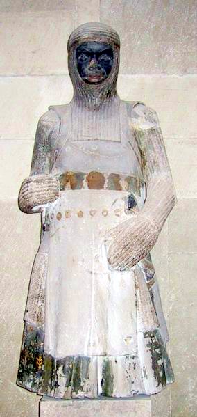
The statue of St. Morris as a black African from the Magdeburg Cathedral
I have added a new chapter to my book, The Enchanting Encounter with the East. The extract belongs to Unit 2, The Saga of All My Sons. The episode delves into the attitude to the race issue in medieval Europe. I show the emergence of the concept which I call the "race fiction", i.e. the superficial and biased approach to differences among people. The literati in the European Middle Ages adopted this outlook from the early church, whose representatives often saw the reality in black and white.
The chapter explains that the color carried many other functions accept the reference to foreign origin and soaring climate. The whiteness was perceived as a sign of superiority, leaving the blackness as a mark of inferior position.
Religion played the major role in people's lives, and any other faith except the Christianity seemed the distortion from the truth. In addition, the Christians in the East were believed to be stuck in heresy. They were welcomed only as a potential ally in the confrontation with Islam.
The case of St. Morris depicted as a black African is exceptional. Its introduction is connected to the eccentric figure of Frederic II, the ruler of the Holy Roman Empire, who was at loggerheads with the Apostolic See.
Thursday, June 1, 2017
The Rediscovered Islands
This is part of my promise to publish new articles on my page at https://scriggler.com/DetailPost/Opinion/63451
While developing articles from my current project into chapters of my second book, I realized that some extracts don't belong to the plot. They are more suitable for my future project about the discovery of India by Portuguese sailors in the course of the 15th century. As usual, the story harks back to the period that I call the Little Age of Discovery.
This is my first contribution to my writer's page on Scriggler after a long time of silence. I will go on uploading other articles. The whole list is available at https://scriggler.com/Profile/michael_baizerman
Friday, April 28, 2017
Where Is the Heart of the World
My next chapter is devoted to the location of Jerusalem on European medieval mind maps.
This is the second part (out of four) of Unit 2, titled The Saga of All My Sons, from my book, "The Enchanting Encounter with the East".

This is the second part (out of four) of Unit 2, titled The Saga of All My Sons, from my book, "The Enchanting Encounter with the East".
The site of Jerusalem on the sixth century Madaba Map
https://en.wikipedia.org/wiki/Madaba_Map
The T-O maps, whose function we cleared up in the previous
discussion, centered Jerusalem amid the circle of lands.
Image 1: Jerusalem,
the Holy City from the sixth century Madaba map mosaic (1)
They did it,
following in the footsteps of the Hebrew Bible, which draws a convincing
picture of the Holy City located at the heart of the world. Ezekiel, the
prophet and the enthusiastic creator of this vision, copies the Lord’s very
words, announcing: “This is Jerusalem, which I have set in the center of the
nations, with countries all around her”. (2)
The idea of the
centrality of Jerusalem was deeply implanted into the Jewish thought. The Book
of Jubilees promotes the three holy places, including Mount Zion, defining it
as “the center of the navel of the earth”. (3)
The Rabbinic
Judaism zooms on the middle point of the earth, visualizing it as a series of
concentric circles of holiness; each inner ring is endowed with diminishing
spatial value against its increasing spiritual worth. The Midrash Tanhuma
Qedoshim argues that the Land of Israel focuses on Jerusalem, the latter on the
Jewish Temple, which in turn shrinks to the Holy of Holies, the Ark, and
eventually to the Foundation Stone, which is the kernel of the world’s creation.
(4)
There was
nothing unusual in favoring one’s homeland as the center of the world and determining
its most sacred site as the midpoint.
The Greek geographer Agathemerus ascribes the same trend to his
countrymen: "the ancients drew the inhabited earth as round, with Hellas
in the middle, and Delphi in the middle of Hellas, since it holds the navel of
the earth." (5)
Western clerics
carried on this concept even further, linking it to the construct of the three
landmasses. St. Jerome’s “Commentary on Ezekiel” defines the City of Peace as
“the navel of the earth”, that is perceived both as the center of the lands and
the focal point of its habitable premises: "from the eastern parts it is
surrounded by… Asia, from the western parts, by… Europe; from the south…
Africa; from the north… by all the nations of the Black Sea. It is therefore
situated in the midst of the peoples.” (6)
In his speech at
the Council of Clermont, Pope Urban II refers to Jerusalem as the cradle of the
Christian faith and the focus of the Christian mission, hailing it the
"navel of the world" and the "paradise of delights". The
bishop of Rome matches the city’s contemporary low profile under the canopy of
the Muslim rule with the tribulations of Jesus:
"This spot the Redeemer of mankind has made illustrious by His
advent, has beautified by His sojourn, has consecrated by His Passion, has
redeemed by His death, has glorified by His burial. (7) According to the papal
interpretation, the life of Jesus had added a new dimension to the Holy City, upgrading
it from the middle point on the globe to its spiritual center.
Saturday, April 15, 2017
The Trefoil of the World
My next chapter, titled "The Trefoil of the World", elaborates on the conventional geographical construct of the three continents forming the habitable world. This image, linked to the scholastic ideas of ancient Greeks and to the Christian philosophy, had further developments throughout the Middle Ages, culminating in detailed "world maps".
Image: Noah’s sons observing their estates from Jean Mansel's illustration to "La Fleur des Histoires" https://www.pinterest.com/dekockmarijke/noah/?lp=true
"Mappamundi, that is
to say, image of the world and of the regions which are on the earth and of the
various kinds of peoples which inhabit it."-The Catalan Atlas (2)
The
cosmographers who contemplated the mysteries of the Earth would employ two
distinct approaches. On the one hand, they mulled over dry land as an orphan island,
whose patchy outlines almost merged with the turbulent waves of the boundless
Ocean. On the other hand, they zoomed in
on the trefoil of continents divorced from each other by overwhelming water
bodies.
These
conventional diagrams, dubbed
T-O maps [Latin: orbis terrarium or “the circle of lands”], reflected the basic
medieval outlook on the inhabited world. The phrase borrowed from Isaiah applies
to the Lord King sitting “enthroned above the circle of the earth”. (3)
T-O
graphs, featuring the “T” inscribed within the “O”, displayed the circle of lands
girdled by a narrow ocean belt. The Mediterranean Sea served the upright pole of
the capital “T”, while the Don River in Russia and the Nile shared the
crossbar. The former “Roman Lake” separated Europe from Africa. The Don cut the
former away from Asia, while the Nile disconnected it from the Dark Continent.
The geographical imagination blew up those water passages to marine proportions.
Not everybody
shared this view. The “father of history” found the tripartite division artificial,
ridiculing the superficial titles attached to the inhabited areas. He argued
that the given names were designated to honor some down-to-earth women, hopefully
of noble origin, rather than glorify heroic men. The Greek historian denounced
the continental construct with its arbitrary boundaries: “I cannot conceive why
three names, and women’s names especially, should ever have been given to a
tract which is in reality one.” (4)
Nevertheless, the image of
the three parts held currency among European scholars. Already for Orosius, an outstanding Christian
historian who lived at the turn of the fourth and fifth centuries, this outlook
was time-honored and respectable: “Our ancestors fixed a threefold division of
the whole world surrounded by a periphery of the Ocean”. (5) A devout author pays
tribute to both classical authors and the fathers of the Church as his recognized
elders.
Thursday, March 30, 2017
Current Issues - March 2017
My new chapter is titled "Four Questions and the World Within". This is a very short and concise conclusion to Unit 1, The Miraculous Revival or the Painful Discovery.
After completing the first part, I addressed my publishing house, GenZ TM, with a proposal to find a beta reader for my book. I would like to listen to some advice, while the project is under way. They agreed to look through Unit 1 and sent me the editor's remarks. This is not what I asked but I am very grateful and even more convinced in following my course.
I am currently working on additions to a new chapter, The Trefoil of the World, from Unit 2.
I continue taking the FutureLearn course, The European Discovery of China, that will help me correct my further units.
My articles on Scriggler has attracted over 16 K visitors. I'm going to give them more food for thought. I decided to remove an essential part, devoted to maritime discoveries, from my book. These chapters are more appropriate for another project, which is too early to think about. However, these pages are liable for publication. You may read any of my nineteen published articles
https://scriggler.com/Profile/michael_baizerman
This blog has recently won recognition from my Russian followers. I'm very flattered with this interest from the readers from my homeland. I would be delighted to have your comments. Generally speaking, my audience is growing and I use this opportunity to congratulate you all with the coming spring holidays. In Israel, where I reside, it is the Passover.
Image: The writer's desktop with the typewriter retro
Source: https://www.shutterstock.com/g/alexkich
Friday, March 17, 2017
How Wide Spans the Ocean Sea

Phoenician cargo ship
Courtesy: https://wikis.engrade.com/phoenicianships
My fourth chapter deals with the issue of the dimensions of the ocean and the perspectives of navigation in the Atlantic.
I describe the voyages of ancient explorers from Egypt to West Africa (Sataspes, Hanno the Navigator) and from India to East Africa (Scylax).
I also recount the views on crossing the Atlantic expressed by philosophers (Aristotle, Eratosthenes, Posidonius, Strabo, Seneca, Pierre d'Ailly), mapmakers (Henricus Martellus, Martin Behaim), and navigators (Christopher Columbus). The chapter is accompanied by the table, Estimation of the Breadth of the Ocean Sea.
This is an extract which refers to the voyage across Africa carried out by Phoenician mariners in the time of Pharaoh Necho:
The first expedition,
commissioned by Pharaoh Necho, who reigned at the turn of the seventh and sixth
centuries BCE, set a task of exploring the confines of the Dark Continent. The
Phoenician mariners, who had staunch reputation for their seamanship, departed
from a port on the Red Sea and after rounding the dry land made a return trip
to Egypt via the Strait of Gibraltar. The food supply on board was enough for
one year. To avoid starvation, the sailors had to rest on their oars twice to
sow a crop of corn. Having picked up the harvest, they were able to move on forward
until by the third year they had completed their heroic undertaking. The most
intriguing part of the report was the observation of the sun traveling through
the north across the right-left arc. The father of history slammed this
testimony as too weird for his straightforward taste. (1)
This account suffers from
many blunders. Since Herodotus does not allude to the source of this report, we
cannot determine its trustworthiness. It is not clear what compelled the
Egyptian monarch to launch this suicidal enterprise and why the Greek historian
shares the pharaoh’s conviction in the possibility of the circumnavigation of
Africa.
Besides, the modern
reconstruction of Herodotus’ world view reveals that the “father of history”
had a vague concept of the outline of the Dark Continent. Its southern fringe rounds
the Atlas Mountains and stretches as far as the mouth of the Red Sea. Even this
fictional voyage across the curtailed continent lasted nearly three years,
demanding two landfalls and a lengthy lingering on the coast.
Image
12: Reconstruction of Herodotus’ World View (2)
The renowned author refuses
to figure out the logistics involved in such venture. His description is too
matter-of-fact and humdrum to be true. He neither explains how Phoenician ships
could withstand daily tackling with unknown coastal currents and winds nor how
they were able to overcome the solitude of a never ending voyage. He doesn’t
report of their encounter with the natives and bizarre wildlife at sea or on
land. He does not refer to any confrontation between the representatives of
antagonistic cultures, though the temporary estrangement of agricultural land
could not pass unnoticed by its lawful owners. Finally, except for the
“perverted” sun, our historian finds no other remarkable astronomical phenomena
in their account; and this particular scoop, proving that the explorers probably
crossed the equator, he does deny.
Even the modern
reconstruction of the journey does not supply any hard evidence. It is
remarkable that a replica of a Phoenician ship rigged with a single square sail
could withstand 20,000-mile voyage during two years. However, unlike ancient
sailors, modern mariners knew their whereabouts and navigated their course,
relying on the GPS and gleaning data from weather maps. They could sail
all-year-round, even in winter, and consume foodstuffs purchased in local
supermarkets. (3)
Saturday, March 4, 2017
How Long Spans the Inhabited World?
Chapter 3 of my book focuses on the classical and medieval estimations of the length of the oikoumene.
I'd like to share with you an extract where Strabo presents his ideas about the graphic representation of the known world and Eratosthenes offers his description of the "human planet".
I'd like to share with you an extract where Strabo presents his ideas about the graphic representation of the known world and Eratosthenes offers his description of the "human planet".
Another argument that flared up the ancient community of
scholars referred to the extent of the oikoumene, i.e.” the world which we
inhabit and know.” (2). Strabo imposed upon a geographer the primary task of
understanding “our inhabited world-its size, shape, and character, and its
relation to earth as a whole”. (3) To achieve this goal, an explorer had to
focus on the “human planet”, omitting the fringes and unfamiliar regions: “the
geographer undertakes to describe the known parts of the inhabited world, but
he leaves out of consideration the unknown parts… as he does what is outside of
it”. (4) The "blank spots" on the map, confined within unsettled territories of deserts and steppes, seemed both unattainable and culturally underdeveloped.
They emitted warning signs not only in spatial, but also in existential sense.
The learned men figured out the oikumene
as a far-flung island which is encompassed by the treacherous waters of the Ocean Sea.
What lay beyond the shoreline was anyone's guess that should not bother a
qualified specialist since his expertise was derived from travel accounts
supported by scientific evidence. Another major source of data was military
campaigns: “The spread of the empires of the Romans and the Parthians has
presented to geographers of today a considerable addition to our empirical knowledge.”
(5)
One could draw this
spacious enclave by connecting its farthest points: “joining with a straight line the extreme
points reached on the coasting voyages made on both sides of the inhabited
world.” (6) A mapmaker would focus on the dry land, marking its major rivers
and main mountain ranges; he takes an interest in the sea only to spot populated islands.
Geography owes its name to
Eratosthenes of Kyrene who baptized a new discipline. An outstanding Greek
scholar and a curator of the Library of Alexandria, he adjusted his virtual
model of the Earth along the prime parallel and meridian, which intersected on
the island of Rhodes in the Aegean Sea.
His entire inhabited world lay
in the Northern Hemisphere. It resembled a soldier's cloak bound tight at the
top and loose at the bottom, with tapered ends in the east and west. Its
northern edge lay on the parallel of Thule (66 degrees North), a legendary
island in the extreme north, while its southern margin extended as far as the
Cinnamon country, (12 degrees North) in southern Sudan, close to the mouth of
the Red Sea, and a mysterious island of Taprobane (Sri Lanka), off the coast of
India. (7)
Subscribe to:
Comments (Atom)