Friday, August 23, 2019

Where is the Heart of the World?

I downloaded another chapter from the second book, "The Enchanting Encounter with the East", on my site https://independent.academia.edu/BaizermanMichael 

 The extract tells about the location of Jerusalem on the European medieval mind maps. 
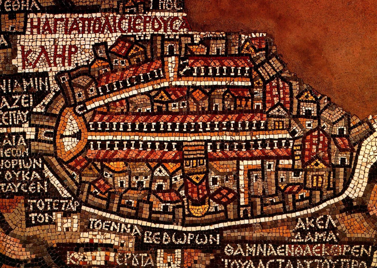
((( Fragment that depicts Jerusalem. Walls are visible around the big cities, including Jerusalem, Jericho, and Ashdod. Jerusalem is the focus of the map. The Madaba Map Centenary, 1897-1997
Throughout the late Middle Ages, Jerusalem functioned as the center of the inhabited world on contemporary 'world maps'. The article discloses various aspects of this spiritual vision which only intensifies after the crusaders' exile from the Holy Land. 

Pope Urban II launched the First Crusade. Saewulf and San Severino were the pilgrims who visited the Holy Land in the 12th and 15th centuries. They both shared the vision of Jerusalem as the navel of the world. 
Sir John Mandeville is a fictitious author of a 14th-century travelog. Prester John is a literary character who attracted European travelers across six centuries. 
Bernard of Clairvaux compared his monastery with the heavenly Jerusalem. 
Isidore of Seville considered the Holy City the center of the region; he seems to be in doubt about the center of the earth. 
Felix Fabri was involved in endless discussions about the centrality of Jerusalem. 
Christopher Columbus advocated a new crusade to restore the Christine dominion of Jerusalem. 

On May 28th I'm going to deliver a lecture about the origin of Israel. I analyze the Stele of Merneptah, the battle reliefs from the Karnak Temple, and the ongoing quest of the settlers in the central hill country during XIII-XI centuries BCE. The lecture will be held in Russian in the Science House at Tel-Aviv. 

Friday, August 9, 2019

The Trefoil of the World

Pietro Vesconte's Mappa Mundi dating the early XIV century

A chapter from my second book, "The Enchanting Encounter with the East" describes the evolution of the mappae mundi, i.e. the 'world maps' of the medieval imagination. These drawings upgrade from simple schemes of Isidore de Seville showing tripartite inhabited earth to more elaborate designs, which incorporate the Ptolemy vision (Hartman Schedel's "The Nuremberg Chronicle") or reflect geographic discoveries ( Heinrich Buntings Cloverleaf Map) or marry with sea charts (Pietro Vesconte). Like an oriental carpet, the brave medieval world of sacred and profane rolls out before your eyes. 

As usual, I would appreciate any comments. You can read this chapter on my site https://independent.academia.edu/BaizermanMichael
where you can find other papers relating either to my second book or my first one, "Dawn and Sunset: A Tale of the Oldest Cities in the Near East". 

I am preparing a lecture on the origin of ancient Israel which is scheduled on August 28th in the Science Club, Tel Aviv. 

I am taking a FutureLearn course, Searching and Researching, which is given by the University of Leeds.

Friday, August 2, 2019

How Long Spans the Inhabited World

I uploaded a new chapter on my site https://independent.academia.edu/BaizermanMichael
This is an extract from Unit I of the book, "The Enchanting Encounter with the East". 

I would appreciate any comments about both the content and the style. 

I began looking for a literary agent to represent my book before a publisher. I will have to write a query letter. 

Meanwhile, I was offered to deliver a lecture about the origin of early Israel before the audience of the scientific club in Tel Aviv. It will be my first public appearance which will take place on August 28. Wish me good luck! 

In this lecture, I am going to analyze the text of Merneptah Stele, the battle reliefs from the Karnak Temple, and the results of the archeological excavations in the central hill country of Judea and Samaria. The material is based on my old paper with numerous additions.