Friday, September 27, 2019

How Wide Spans the Ocean Sea

Courtesy: John Carlton 

I am remodeling my old article titled "How Wide Spans the Ocean Sea".  It consists of two parts. The first section covers maritime explorations carried out during the VI and V centuries BCE; it was so vividly described by Herodotus. We refer to the Phoenician expedition which is reported to have circumnavigated Africa, as well as the exploits of Sataspes, Scylax of Caryanda, and Hanno the Navigator. 
  
The other segment collects the views of classical and medieval geographers concerning the prospect of crossing the Atlantic Ocean that was believed to separate Spain (or, in another version, Marocco) from China and Japan.  These scholars discuss such issues as the existence of a landmass in between or an unbroken expanse of the deep blue. Among them, we find Aristotle, Eratosthenes, Posidonius, Strabo, Seneca, Augustine, as well as Pierre d'Ailly, Henricus Martellus, Martin Behaim, and Christopher Columbus. 

This paper was originally part of my second book, The Enchanting Encounter with the East. However, since the keynote of this volume is the overland communication, I decided to take out this extract. It lay idle while I was investigating the initial topics of my third project, the search for the maritime access to India from Europe. A not long time ago, I decided to insert this extract. 

I can't publish it now as I need to do another research which entails unavoidable corrections. Hopefully, I will upload it soon.

Meanwhile, my site https://independent.academia.edu/BaizermanMichael has attracted over five hundred readers; the good news obliges me to start writing a query letter for my second book. 

This blog has been honored by more than 2800 visits. Special thanks to my American and Ukrainian readers. I would be thankful for any comments. 


Friday, September 20, 2019

The Enigma of the Antipodes

A new chapter from my second book, 'The Enchanting Encounter with the East", presents the ideas of classical and medieval literati on the existence and character of the fourth part of the world. That was a controversial notion that could bring trouble to its carriers because it bordered with heresy. 

The medieval concept of the Antipodes was the brainchild of the classical philosophic discourse about the latitudinal zones. The interaction between the pair of inhabited zones was null and void because these counterpart worlds were separated by impregnable obstacles: the searing Torrid Zone and the unbounded equatorial ocean. 

The issue of the extent of the inhabited world was mingled with the reach of the Christian mission since the word of God had to permeate the earth's furthest fringes.  

The hypothesis of the Antipodes raised the practical issue of circumnavigation. 

The above illustration is called Burgo de Osma Mappamundi
This is an eleventh-century copy of the Mappa Mundi created to illustrate Beatus of Liebana commentary on the Apocalypse. In the right section of the chart, which corresponds to the southern area, the fantastic Sciapod raises his single leg to find shade from the merciless sun. 

Friday, September 6, 2019

In Black and White: The Racial Mentality in the European Middle Ages

A chapter from Unit II of my book, The Enchanting Encounter with the East, studies medieval racial theories uttered by outstanding European scholars and endorsed by the Roman Catholic Church. 
Image: Healing of the Gadarene Demoniacs
https://networks.h-net.org/race-european-middle-ages-image-healing-gadarene-demoniacs

I study the applications of the racist ideology which I find amid western intellectuals who flourished across the European Middle Ages. Their views were endorsed by the Church which encouraged the European monarchs to take to the road of expansion. I check the echoes of these opinions in art,  architecture, poetry, and even in contemporary medical treaties. 
 The only exception to the rule is the statue of St.Moris erected in the Magdeburg Cathedral. 
https://en.wikipedia.org/wiki/Saint_Maurice#/media/File:Saint_Maurice_Magdeburg.jpg
The character of a black warrior in the attire of a medieval knight suited Frederick II, the sovereign of the Holy Roman Empire, in his strife with the Pope. 

Friday, August 23, 2019

Where is the Heart of the World?

I downloaded another chapter from the second book, "The Enchanting Encounter with the East", on my site https://independent.academia.edu/BaizermanMichael 

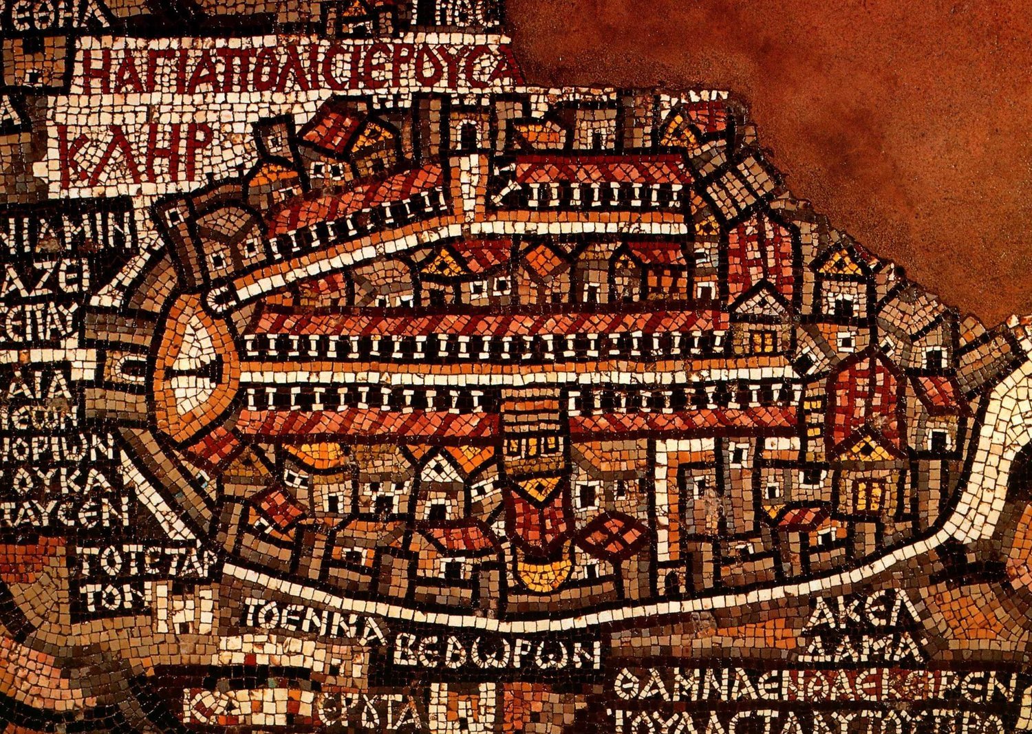
 The extract tells about the location of Jerusalem on the European medieval mind maps. 

((( Fragment that depicts Jerusalem. Walls are visible around the big cities, including Jerusalem, Jericho, and Ashdod. Jerusalem is the focus of the map. The Madaba Map Centenary, 1897-1997
Throughout the late Middle Ages, Jerusalem functioned as the center of the inhabited world on contemporary 'world maps'. The article discloses various aspects of this spiritual vision which only intensifies after the crusaders' exile from the Holy Land. 

Pope Urban II launched the First Crusade. Saewulf and San Severino were the pilgrims who visited the Holy Land in the 12th and 15th centuries. They both shared the vision of Jerusalem as the navel of the world. 
Sir John Mandeville is a fictitious author of a 14th-century travelog. Prester John is a literary character who attracted European travelers across six centuries. 
Bernard of Clairvaux compared his monastery with the heavenly Jerusalem. 
Isidore of Seville considered the Holy City the center of the region; he seems to be in doubt about the center of the earth. 
Felix Fabri was involved in endless discussions about the centrality of Jerusalem. 
Christopher Columbus advocated a new crusade to restore the Christine dominion of Jerusalem. 

On May 28th I'm going to deliver a lecture about the origin of Israel. I analyze the Stele of Merneptah, the battle reliefs from the Karnak Temple, and the ongoing quest of the settlers in the central hill country during XIII-XI centuries BCE. The lecture will be held in Russian in the Science House at Tel-Aviv. 

Friday, August 9, 2019

The Trefoil of the World

Pietro Vesconte's Mappa Mundi dating the early XIV century

A chapter from my second book, "The Enchanting Encounter with the East" describes the evolution of the mappae mundi, i.e. the 'world maps' of the medieval imagination. These drawings upgrade from simple schemes of Isidore de Seville showing tripartite inhabited earth to more elaborate designs, which incorporate the Ptolemy vision (Hartman Schedel's "The Nuremberg Chronicle") or reflect geographic discoveries ( Heinrich Buntings Cloverleaf Map) or marry with sea charts (Pietro Vesconte). Like an oriental carpet, the brave medieval world of sacred and profane rolls out before your eyes. 

As usual, I would appreciate any comments. You can read this chapter on my site https://independent.academia.edu/BaizermanMichael
where you can find other papers relating either to my second book or my first one, "Dawn and Sunset: A Tale of the Oldest Cities in the Near East". 

I am preparing a lecture on the origin of ancient Israel which is scheduled on August 28th in the Science Club, Tel Aviv. 

I am taking a FutureLearn course, Searching and Researching, which is given by the University of Leeds.

Friday, August 2, 2019

How Long Spans the Inhabited World

I uploaded a new chapter on my site https://independent.academia.edu/BaizermanMichael
This is an extract from Unit I of the book, "The Enchanting Encounter with the East". 

I would appreciate any comments about both the content and the style. 

I began looking for a literary agent to represent my book before a publisher. I will have to write a query letter. 

Meanwhile, I was offered to deliver a lecture about the origin of early Israel before the audience of the scientific club in Tel Aviv. It will be my first public appearance which will take place on August 28. Wish me good luck! 

In this lecture, I am going to analyze the text of Merneptah Stele, the battle reliefs from the Karnak Temple, and the results of the archeological excavations in the central hill country of Judea and Samaria. The material is based on my old paper with numerous additions. 

Thursday, July 25, 2019

How to Measure the Earth's Circumference

Hopefully, you are perfectly aware of it. However, back in time scholars would come up with educative guesses about the Earth's circumference.

This is the story of various evaluations. I made an effort to convert ancient measures into modern ones to show you the margin of deviation. To do this, I blend all the known samples of these measures into a 'consensus value', which is the average meaning. I refer to the stadium, Arab mile, and Roman mile. I mention Eratosthenes, Posidonius, Pierre d'Ailly, Ahmad Al-Farghani, and Christopher Columbus. 

This is the second chapter of my book, "The Enchanting Encounter with the East". You can also view chapter 1: What If the Earth is the Sphere.

My website gets attention from people around the world with more than 250 hits. I intend to continue uploading other parts of my second book.

Meanwhile, I decided to review my first book, "Dawn and Sunset". I research new info about the origin of the first cities in Mesopotamia.

I got a proposal to read a lecture about the Hyksos in a public hall in Tel Aviv. I am excited since it is going to be my first public appearance. I got interested in the Hyksos while looking for a theme to enlighten the history of ancient Israel. 

Several years ago, when I was working on the paper devoted to the origins of ancient Israel, I became convinced that the Israelites are part of the land of Canaan. In other words, Exodus is a terrific myth. 

Suddenly, I got the idea for my fourth project. I should start the history of ancient Israel not with the Stela of Merneptah but with the description of the Canaanites. One of the implications is the story of the Hyksos, the members of the Canaanite elite who rose to power in the Nile Delta. I am currently collecting material for this lecture. Wish me good luck. I really need it.